
By Alec Go
Super Typhoon “Mawar” may retain its strength or continue to intensify as it moves towards the Philippine Area of Responsibility (PAR), the weather bureau said Friday afternoon, May 26.
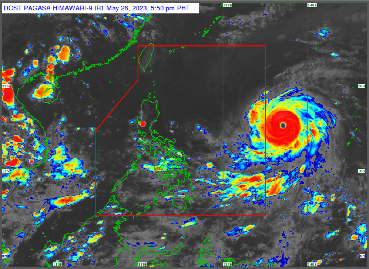
As of 3:00 p.m., the super typhoon is at 1,725 kilometers (km) east of Central Luzon with maximum sustained winds of 215 km per hour (km/h) and gustiness of 265 km/h. It is moving west northwestward at 25 km/h.
“Either inaasahan nating magpapatuloy itong lakas or mame-maintain ni ‘Mawar’ ang lakas na 215 km/h or posibleng mas lumakas pa ito into 220 km/h within the next one to two days,” PAGASA weather specialist Daniel James Villamil said.
It is forecast to enter the country between Friday night and early Friday morning.It will be called “Betty” once it enters PAR.
“Habang papalapit itong si Mawar, ang rain bands o yung direktang ulan na dala nito ay posibleng mahagip ang mga lalawigan ng Cagayan Valley [and the] northern portion of Aurora,” Villamil said, adding that heavy rains will be experienced Sunday evening until Monday.
“Sa hangin namang dala ni Mawar, strong to storm force na mga hangin ang posible nating maranasan sa mga baybayin, partikular sa mga probinsiya ng extreme northern luzon. Strong to gale force naman ang ating inaasahan sa hilaga at silangang bahagi ng mainland northern Luzon,” he added.
Tropical cyclone wind signals may be hoisted starting Saturday afternoon or evening.
PAGASA said “Mawar” may also intensify southwest monsoon (habagat) while it moves towards the Philippine landmass and may trigger rains over western portions of Central Luzon,southern Luzon, and Visayas beginning Sunday or Monday.
PAGASA said “Mawar” may be downgraded into typhoon category by Monday while tracking the east of extreme northern Luzon area “due to unfavorable conditions,” and will continue to weaken by Monday and Tuesday.
No gale warnings have been issued as of posting. – gb